




LiDAR App Development for Advanced 3D Mapping Solutions
Blog Summary:
LiDAR technology is revolutionizing industries through advanced 3D scanning, spatial mapping, and real-time data insights. This blog explores LiDAR App Development, including its benefits, features, technologies, cost, and future trends for building innovative applications.
Imagine capturing rooms, construction sites, or landscapes within seconds with exceptional precision. LiDAR App Development enables intelligent applications that use spatial mapping, real-time data capture, advanced visualization to improve accuracy, efficiency, and decision-making across industries.
Advanced spatial applications combine laser-based sensing, artificial intelligence, augmented reality, and cloud technologies to generate detailed 3D models, detect objects, and deliver immersive user experiences.
As smartphones, tablets, drones, and specialized devices continue to integrate advanced depth-sensing capabilities, demand for LiDAR-powered solutions is rapidly increasing.
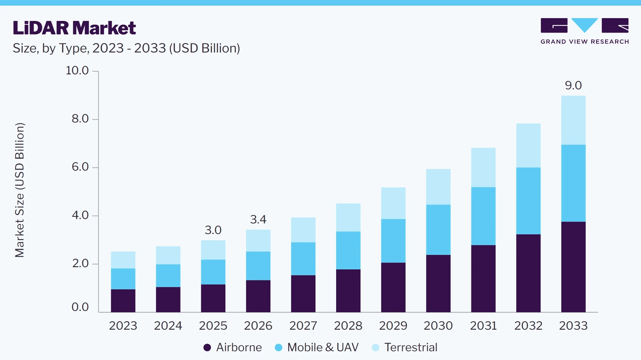
According to a report by Grand View Research, the rapid adoption of LiDAR technology is reflected in its expanding global market.
Market Size in 2025: USD 3.0 Billion, Estimated Market Size in 2026: USD 3.4 Billion, Projected Market Size by 2033: USD 9.0 Billion, with a CAGR (2026–2033) of 14.8%.
Autonomous systems drive this growth, Advanced Driver Assistance Systems (ADAS), higher-resolution sensors, declining hardware costs, and the increasing adoption of electric vehicles.
Beyond automotive applications, LiDAR-powered solutions support digital twins, indoor navigation, warehouse automation, property visualization, healthcare, retail, and smart city initiatives.
This guide explores LiDAR technology, its benefits, scanner types, use cases, key features, technologies, development costs, future trends, and how to build scalable, high-performance LiDAR applications.
What is LiDAR?
LiDAR (Light Detection and Ranging) is a remote sensing technology that uses laser pulses to measure distances and create highly accurate 3D models of physical environments.
A LiDAR scanner captures thousands of measurements every second, generating point cloud data for mapping, navigation, and visualization.
With advanced LiDAR sensors now integrated into smartphones, tablets, drones, and industrial equipment, the technology has become more accessible.
As a result, LiDAR App Development is enabling innovative solutions for industries such as construction, healthcare, real estate, logistics, and retail by delivering accurate spatial data, improved efficiency, and enhanced user experiences.
Benefits of LiDAR Technology
LiDAR technology uses laser pulses to capture accurate spatial data for precise 3D mapping and depth measurement. It helps businesses improve efficiency, reduce manual errors, and make better decisions across industries.
High Accuracy
LiDAR delivers highly precise distance and depth measurements, making it ideal for applications that require detailed spatial data. It minimizes manual measurement errors and improves the accuracy of mapping, surveying, and inspection tasks.
Fast Data Collection
Unlike traditional measurement methods, LiDAR captures millions of data points within seconds. This enables quicker site surveys, room scans, and infrastructure assessments, significantly reducing project timelines.
3D Mapping Capabilities
One of the biggest advantages of LiDAR is its ability to generate detailed 3D models of indoor and outdoor environments. These digital representations help businesses visualize spaces, plan projects, and analyze environments more effectively.
Real-time Object Detection
Powered by advanced lidar technology, LiDAR systems can detect and identify surrounding objects in real time.
This capability is essential for applications such as autonomous navigation, AR experiences, robotics, and safety monitoring, where instant environmental awareness improves performance and decision-making.
How Do LiDAR Sensors Work?
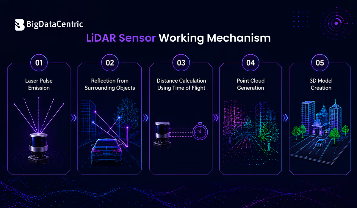
LiDAR systems measure the distance between the sensor and surrounding objects by emitting laser pulses and analyzing the reflected signals. This process generates accurate spatial data that is used to create detailed 3D models, digital maps, and immersive AR experiences.
Laser Pulse Emission
The sensor emits thousands of laser pulses every second toward surrounding objects. These pulses travel at the speed of light, enabling rapid and highly accurate data collection across both indoor and outdoor environments.
Reflection from Surrounding Objects
When laser pulses strike surfaces such as walls, buildings, furniture, or terrain, they reflect back to the sensor. The returning signals provide precise information about an object’s location, shape, and distance.
Distance Calculation Using Time of Flight
The system measures the time it takes each laser pulse to travel to an object and return. This Time-of-Flight (ToF) calculation determines accurate distances for every scanned point.
Point Cloud Generation
Millions of measured points are combined to create a dense point cloud. This digital dataset accurately represents the geometry, dimensions, and surface details of the scanned environment.
3D Model Creation
The generated point cloud is processed into detailed 3D models that support mapping, virtual visualization, construction planning, navigation, asset inspection, and numerous other business applications.
Build Intelligent LiDAR Solutions
Create custom LiDAR apps that deliver accurate scanning, mapping, and immersive experiences.
Different Types of LiDAR Scanners
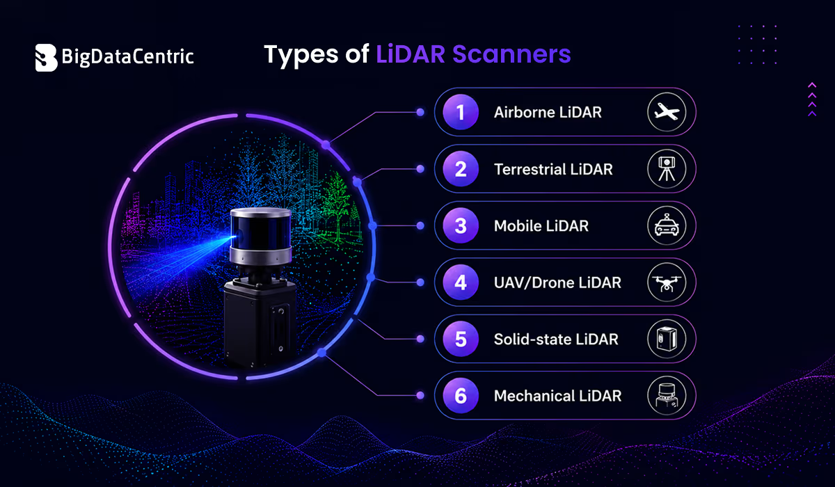
Different LiDAR systems are designed for specific environments and applications. Choosing the right scanner depends on factors such as accuracy requirements, mobility, coverage area, and project objectives.
Airborne LiDAR
Mounted on airplanes or helicopters, airborne LiDAR is ideal for capturing large-scale geographic data.
It is widely used for topographic mapping, forestry management, flood risk assessment, environmental monitoring, and infrastructure planning, providing accurate data over extensive areas in a short time.
Terrestrial LiDAR
Terrestrial LiDAR is installed on a fixed tripod or stationary platform to capture highly detailed scans of buildings, bridges, roads, tunnels, and historical monuments.
It is commonly used for land surveying, construction documentation, structural inspections, and the creation of accurate digital twins.
Mobile LiDAR
Mobile LiDAR systems are mounted on vehicles, backpacks, or handheld devices, enabling continuous scanning while in motion.
They are commonly used for road mapping, railway inspections, smart city development, utility asset management, and transportation infrastructure projects where rapid data collection is essential.
UAV/Drone LiDAR
UAV or drone-mounted LiDAR combines aerial flexibility with high-precision scanning to survey hard-to-reach locations.
It is extensively used in mining, agriculture, power line inspections, environmental conservation, disaster response, and terrain analysis while reducing operational time and costs.
Solid-State LiDAR
Solid-state LiDAR eliminates moving mechanical components, making the system smaller, more durable, and energy-efficient.
Its compact design makes it ideal for smartphones, robotics, autonomous vehicles, and consumer electronics that require reliable depth sensing and long-term performance.
Mechanical LiDAR
Mechanical LiDAR uses rotating mirrors or laser assemblies to provide a comprehensive 360-degree view of the surrounding environment.
It offers exceptional accuracy and long-range detection, making it ideal for autonomous vehicles, robotics, advanced mapping, and workflow automation in industrial operations and smart manufacturing.
Use Cases of LiDAR Apps
LiDAR-powered applications deliver accurate spatial data, 3D experiences, and real-time measurements, helping industries improve efficiency, reduce errors, and make smarter decisions.
Architecture and Interior Design
- Room Scanning: Quickly captures accurate room dimensions, walls, doors, windows, furniture, and layouts, making interior planning, remodeling, and renovation projects faster and more precise.
- Floor Plan Generation: Converts scanned spatial data into detailed 2D and 3D floor plans, improving visualization, architectural planning, project collaboration, and design accuracy.
Construction and Engineering
- Site Measurements: Captures highly accurate site measurements in minutes, reducing manual surveying efforts, minimizing errors, and improving planning for construction and infrastructure projects.
- Building Inspections: Create detailed 3D models of buildings to identify structural issues, monitor project progress, simplify inspections, and support predictive maintenance planning.
Real Estate
- Virtual Property Tours: Create immersive virtual property tours that let potential buyers explore homes remotely, saving time and enhancing the viewing experience.
- Space Visualization: Visualize room dimensions, layouts, and furniture placement to help buyers and designers better understand available space before making decisions.
Healthcare
- Patient Monitoring: Monitor patient movements, posture, and mobility accurately without physical contact, enabling continuous health assessment while enhancing patient comfort and safety.
- Rehabilitation Support: Track body movements and recovery progress in real time, allowing healthcare professionals to deliver personalized rehabilitation programs and measure treatment effectiveness.
Retail and E-commerce
- AR Product Visualization: Enable customers to preview furniture, home décor, and other products in their actual spaces using augmented reality before making a purchase.
- Furniture Placement: Place virtual furniture accurately based on room dimensions to help customers optimize space planning and make more confident buying decisions.
Gaming and Entertainment
- Immersive AR Experiences: Develop realistic augmented reality games in which virtual objects interact naturally with real-world environments, creating more engaging, interactive gameplay.
- Environment Scanning: Scan indoor and outdoor surroundings to build interactive gaming environments with accurate object recognition, positioning, and realistic spatial interactions.
Logistics and Warehousing
- Inventory Mapping: Generate detailed 3D maps of warehouses and storage areas to improve inventory organization, maximize space utilization, and increase overall operational efficiency.
- Navigation: LiDAR supports indoor navigation for workers, robots, and automated vehicles, enabling safer movement and faster order fulfillment within warehouses.
Automotive and Autonomous Vehicles
- Obstacle Detection: Detect pedestrians, vehicles, road signs, and obstacles in real time, helping autonomous systems make safer driving decisions and avoid collisions.
- Navigation Systems: Power high-precision navigation with real-time mapping, route optimization, lane detection, and collision avoidance for safer and more reliable autonomous driving.
Transform Your Business with LiDAR Apps
Leverage custom LiDAR app development to improve accuracy, automate workflows, and build innovative 3D and AR solutions for your business.
Features of a LiDAR App Development
A successful LiDAR application combines powerful features with the right technology stack to ensure accurate scanning, real-time processing, secure data management, and seamless performance.
Real-time 3D Scanning
Capture highly accurate three-dimensional environments instantly, enabling fast mapping, spatial analysis, and realistic visualization for various industries.
Depth Detection
Measure the distance between objects with exceptional precision using advanced laser-based depth sensing, ensuring reliable data for scanning and navigation.
Object Recognition
Automatically identify, classify, and track objects using AI-powered image processing to improve automation and enhance decision-making.
Surface Measurement
Accurately calculate surface dimensions, area, volume, and elevation, reducing manual measurements and improving project accuracy.
Point Cloud Visualization
Generate and display detailed point cloud data for interactive 3D modeling, analysis, and digital reconstruction of real-world environments.
AR Integration
Overlay digital objects and information onto real-world environments, creating immersive augmented reality experiences for visualization, training, and product demonstrations.
Cloud Data Storage
Securely store, synchronize, and manage scanned data in the cloud, enabling easy access, collaboration, and backup across multiple devices.
AI-powered Analysis
Leverage artificial intelligence to analyze spatial data, detect patterns, generate actionable insights, and automate complex workflows with greater accuracy.
Offline Mode
Allow users to perform scanning, measurements, and data collection without an internet connection, ensuring uninterrupted productivity in remote locations.
Cross-platform Compatibility
Ensure consistent performance and user experience across iOS, Android, tablets, and LiDAR-enabled devices while maintaining seamless data synchronization.
Technologies Used for LiDAR App Development
The right technology stack ensures a LiDAR application delivers high performance, accuracy, scalability, and a seamless user experience across supported devices.
Programming Languages
- Swift: The preferred language for developing high-performance iOS applications with native support for Apple’s LiDAR-enabled devices, delivering smooth performance and seamless integration with ARKit.
- Kotlin: Google’s recommended language for building secure, modern, and scalable Android applications with improved code safety, maintainability, and performance.
- C#: Widely used with Unity to develop cross-platform AR, VR, and 3D applications, enabling faster development and interactive user experiences.
- C++: provides high-performance processing for complex 3D rendering, point cloud management, real-time calculations, and graphics-intensive operations.
Frameworks and SDKs
- Apple ARKit: Enables advanced augmented reality experiences with native LiDAR support, including environment scanning, motion tracking, and depth sensing on compatible Apple devices.
- RealityKit simplifies 3D rendering, animations, physics simulation, and real-time interactions, making it easier to build immersive AR applications.
- SceneKit: Helps developers create, manage, and render complex 3D scenes using Apple’s powerful graphics framework with minimal development effort.
- Unity: A leading game engine for building interactive 3D, AR, and VR applications across iOS, Android, Windows, and other supported platforms.
- Unreal Engine: Delivers photorealistic graphics, advanced rendering capabilities, and high-performance visualization for enterprise, simulation, and gaming applications.
Cloud Platforms
- AWS: Offers secure cloud storage, scalable computing, server-less services, analytics, and backend infrastructure for enterprise-grade LiDAR applications.
- Google Cloud: Supports AI, machine learning, real-time data processing, cloud storage, and secure application management for intelligent LiDAR solutions.
- Microsoft Azure: Provides enterprise-grade cloud services, authentication, data storage, application hosting, and security features for scalable deployments.
Database and APIs
- Data Storage Solutions: Securely store point cloud data, 3D models, user information, scanned images, and project files while ensuring fast access and reliable backup.
- Third-Party API Integrations: Connect mapping, geolocation, analytics, authentication, payment, and location-based services to extend application functionality.
- Real-Time Data Synchronization: Synchronize scanned data, project updates, and user activities across multiple devices and team members for seamless collaboration.
- Backend Services: Handle user authentication, file processing, cloud storage, notifications, data management, and overall application functionality with secure and scalable architecture.
Understand the LiDAR App Development Process
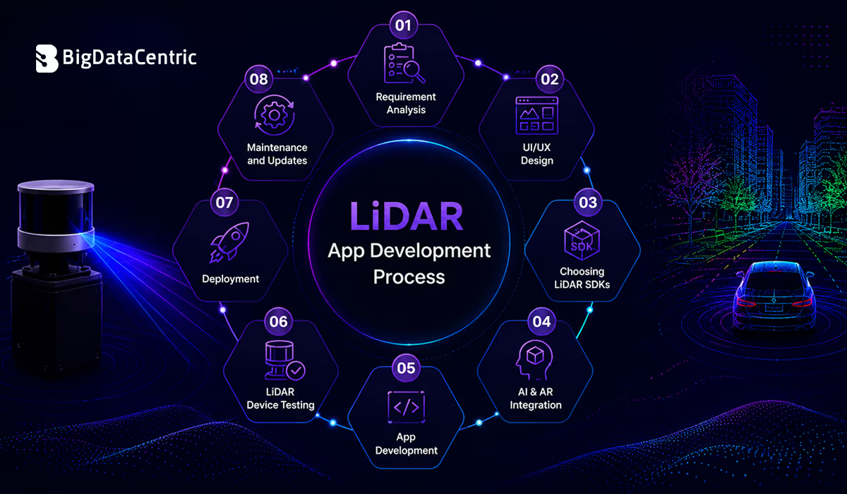
Developing a LiDAR application requires careful planning, the right technology stack, and thorough testing to ensure accurate scanning and a seamless user experience. Below are the key stages involved in the development process.
Requirement Analysis
The process begins by identifying business goals, target users, supported devices, and core functionalities. Developers also define industry-specific requirements, technical feasibility, and project scope before development starts.
UI/UX Design
Designers create intuitive wireframes, user flows, and interactive prototypes that make scanning, navigation, and data visualization simple while ensuring a smooth user experience across supported devices.
Choosing LiDAR SDKs
The appropriate SDKs and development frameworks are selected based on the target platform and project requirements. This ensures compatibility, accurate depth sensing, and efficient 3D data processing.
AI & AR Integration
Artificial intelligence enhances object recognition and data analysis, while augmented reality enables users to interact with virtual objects within real-world environments for immersive experiences.
App Development
Developers build the frontend, backend, and core scanning modules while integrating features such as 3D mapping, object detection, cloud connectivity, and secure data management.
Testing on LiDAR-Compatible Devices
The application is tested on supported smartphones, tablets, and other compatible devices to verify scanning accuracy, performance, responsiveness, and overall reliability under different conditions.
Deployment
After successful testing, the application is deployed to app stores or enterprise environments with proper configuration, security checks, and compliance with platform guidelines.
Maintenance and Updates
Ongoing maintenance is essential to keep LiDAR applications secure, stable, and compatible with evolving devices, operating systems, and emerging technologies.
How Much Does LiDAR App Development Cost?
The cost of LiDAR App Development typically ranges from $20,000 to $200,000+, depending on the application’s complexity, supported platforms, required features, AI and AR capabilities, cloud infrastructure, and third-party integrations.
Basic apps require a lower investment, while enterprise-grade solutions with advanced 3D scanning, real-time analytics, and custom functionality involve higher development costs.
Get a Custom LiDAR App Cost Estimate
Share your project requirements with our experts and receive a tailored cost estimate for your LiDAR app development needs.
Future of LiDAR App Development
As LiDAR capabilities continue to advance, businesses can expect more intelligent, accurate, and scalable applications. The future of LiDAR-powered solutions will be driven by innovations in hardware, AI, and spatial computing.
- Wider Smartphone Adoption: More smartphones, tablets, and wearable devices will integrate LiDAR sensors, making advanced 3D scanning, room mapping, and augmented reality experiences accessible to a broader audience.
- Better Sensor Accuracy: Next-generation LiDAR sensors will provide faster scanning speeds, higher precision, improved depth perception, and enhanced performance in both indoor and outdoor environments.
- Expansion of AR/VR Applications: LiDAR will power richer augmented and virtual reality experiences through accurate environmental mapping, real-time object tracking, and realistic interactions between digital and physical environments.
- Growth in Autonomous Systems: Autonomous vehicles, drones, robots, and industrial equipment will leverage LiDAR for smarter navigation, real-time obstacle detection, path planning, and safer autonomous operations.
- Enterprise Digital Transformation: Organizations will adopt LiDAR applications to support enterprise digital transformation, automate inspections, optimize workflows, improve asset management, and enhance operational efficiency through accurate spatial data.
- Industry-Specific Innovations: New LiDAR-powered solutions will continue to emerge in healthcare, retail, construction, logistics, manufacturing, agriculture, and smart cities, addressing industry-specific challenges with greater accuracy and efficiency.
Why Choose BigDataCentric for LiDAR App Development?
BigDataCentric specializes in building innovative LiDAR-powered applications tailored to diverse business needs.
Our team leverages expertise in AI, AR, cloud computing, and 3D visualization to develop secure, scalable, and high-performance solutions that deliver accurate spatial insights, seamless user experiences, and measurable business value across multiple industries.
From strategy and UI/UX design to development, deployment, and ongoing support, BigDataCentric provides end-to-end development services.
We follow agile methodologies, ensure transparent communication, and focus on quality, scalability, and long-term success, helping businesses accelerate digital transformation with reliable and future-ready LiDAR applications.
Conclusion
LiDAR is transforming how businesses capture, analyze, and interact with the physical world through accurate 3D mapping and real-time spatial intelligence.
As adoption continues to grow across industries, investing in a well-designed LiDAR application can improve efficiency, enhance decision-making, and unlock new business opportunities.
Partnering with an experienced development team ensures a scalable, secure, and future-ready solution tailored to your unique business requirements.
FAQs
Does Apple have a LiDAR app?
Yes, Apple provides LiDAR capabilities through devices with built-in LiDAR sensors, such as certain iPhone and iPad Pro models. Apps like Measure use this technology for distance measurement, room scanning, and creating 3D space representations.
Is LiDAR a growing industry?
Yes, LiDAR is a rapidly growing industry driven by increasing adoption in areas like autonomous vehicles, construction, healthcare, robotics, smart cities, and augmented reality applications.
What are the 4 components of LiDAR?
The four main components of LiDAR are the laser source, scanner, GPS/positioning system, and sensor receiver. Together, they capture, process, and analyze accurate spatial data.
Is the LiDAR app free?
Many LiDAR apps offer free versions with basic features, while advanced applications may require paid plans or subscriptions. Availability depends on the app’s features and supported devices.


Jayanti Katariya is the CEO of BigDataCentric, a leading provider of AI, machine learning, data science, and business intelligence solutions. With 18+ years of industry experience, he has been at the forefront of helping businesses unlock growth through data-driven insights. Passionate about developing creative technology solutions from a young age, he pursued an engineering degree to further this interest. Under his leadership, BigDataCentric delivers tailored AI and analytics solutions to optimize business processes. His expertise drives innovation in data science, enabling organizations to make smarter, data-backed decisions.


